This is a test of the iPad blogging software for WordPress. Should there really be a blog when we travel you should Read accordingly. What’s going to be the most problematic is getting photos from my iPhone to my iPad. And I don’t think we’ll be able to format photos left right center.
Author Archives: tg
Weminuche Loop
This jagged red track on the topo represents about 3 of 5 days recently spent in the Alpine regions of the Weminuche Wilderness of the San Juan Mountains just northeast of Durango. Without a question this was one of the most beautiful (and adventurous) trips I’ve made in a number of years. Putting my ultralight gear to the test was just one of the features of this high country trek of about 53 miles with approximately 16,200′ of elevation gain and a corresponding 18,100′ of descent.
It’s a wonder that we don’t have to go to far-off regions of the world for an alpine experience, because we have such an amazing 488,210 acres of true wilderness so close to home. The San Juan National Forest, of which the Weminuche is a quarter, is almost 3,000 square miles. Before this trip, I had only “dabbled” in this expansive wonderland, with most trips very near to Trailheads and access roads. Once we got a couple miles in on the Cave Basin trail north of Vallecito Reservoir, we left the beaten trail and rarely trod on designated trails again until we exited the high country at Chicago Basin on the 6-mile downhill route to catch the Silverton Narrow Gauge train at it’s wilderness stop at Needleton. It’s not unusual to have afternoon thunderstorms come thru the San Juans, but we hit the jackpot of adverse weather the first night, when we had hard hail, followed by wet snow, and then another round of hail for a couple of hours.
Holed up in each of our tents we were dry and warm but the “trim” of the tent shape suffered when loaded down with snow and ice.
I’ve signed up to be a Wilderness Information Specialist as a volunteer for the National Forest Service and lucked out to have my indoctrination with Will Rietveld a long time resident of Durango and intimate of San Juans. He prefers to hike off-trail, above tree line, and no longer requires a map. So we spent most of those 5 days high up in the alpine regions of the San Juans, only venturing down into the thinned tree line long enough to contour or traverse up to another pass and on to the next drainage.
We had much in common, most notably an interest in ultralight backpacking gear, as he’s been an ultralight gear editor and writer/reviewer for some online and print publications for over 10 years. Our gear was very similar and/or he knew all about my choices, their weights and usefulness. Needless to say I took copious notes on how to tweak my gear and skills.
The first four days we only saw three hiking parties and that was when we dropped down to drainages that had established trails. Wearing a Forest Service shirt seems to make folks friendlier and it was fun to “chat them up.” We didn’t see many live elk, however there were numerous mule deer, ptarmigan,and mountain goats, plus the ubiquitous pica and marmots. We were too high to encounter any bear as the foraging above tree line is non-existant.
The high point, both literally and figuratively, was climb up the east side of the pass between Sunlight and Windom peaks at first light the last morning. Our morning snack at 6:45 am was in the notch at 13,700′ between two of the most popular 14’ers in the Weminuche.
Oh, Will did find an arrowhead about 50′ from one of our tent sites. Which, according to the rules of the National Forest, remains right where he found it. Here’s hoping that I can remember his shortcuts and routes across that spectacular country.
Weekend Bash
On this hike I rarely took time to smell the flowers. It’s the end of July and the wildflowers are still prolific at altitude and the Colorado Columbine always catches your eye. It just wasn’t a hike that I wanted to take the time to get the iPhone camera out and snap away. Besides I’d just done this exact route either last year or the year before on my mountain bike.
The occasion to duplicate a route I’d just recently done, was that it was some place with sufficient distance, close to home and where I could snag a ride to the trailhead without inconveniencing anyone (thanks Christopher). I’ve wanted to know, ever since I met a thru hiker (incidentally on this same trail while I was mountain biking) who had averaged 33 miles per day out of Denver on the 550 mile Colorado Trail to Durango. He’s the first UltraLight hiker I ever met and I was fascinated on how it was possible to cover over 30 miles a day with a backpack.
Now that I am an UltraLight backpacker I’ve wanted to learn how many miles I could cover in a day (realizing that he’d done that for over 14 days in a row). With several time constraints, re-covering the same segment of the Colorado Trail made perfect sense, so I hastily packed my gear and hitched a ride to Molas Pass above Silverton. Starting just before noon on Saturday I managed to make my goal at the top of Junction Creek by Sunday noon. (Daniel and grand girls were arriving from Portland late Sunday).
Every hike is a shake down, but this one had several things I wanted to test, besides my body. New hiking shoes, the iPhone Gaia GPS system, new poles, a SteriPen water purifier and most important how fast I could travel with 8.5# of base weight in my pack. I’m sure I started out too fast, because at the 3 hour mark, when I took my first break, another UL hiker breezed by and I never saw him again.
First day there was no rain, only loud clatterings of thunder and lots of lightening south of my track. I managed 20.5 miles when I quit walking at 8 PM, this was just shy of my first mt.bike camp from the year before. Next day looked wonderful, and I was doing great until I missed a trail marker when I merged into a forest service road. Evidently the route was just 100 yards up the road to the right, but I was expecting the trail to go left and missed the trail entirely. I followed 4 mt. biker tracks I’d seen pass me earlier, down a trail I later learned was Hotel Draw, and it was well over an hour before I realized I was on a descending ridge to the east of where I was supposed to be. Turning around an hiking uphill an hour was a hard decision, but once I got back on the right trail I was glad I had.
I was trying to make 30 miles that day but fell about a half mile short when I chose a campsite just below a towering scree slope at 8:30 PM, with rain starting to close in. I’d stopped about 6 PM during a short squall to cook dinner in the trees, so all I had to do was put up the tent and bed down. Funny thing I learned was, my body was so sore that I couldn’t get to sleep. No position was comfortable and it took 2 ibuprofen at midnight to settle me down. Heavy rain all night tested my newest UL tent and proved it dry. I’ve seldom, if ever, broke camp in the rain but Sunday morning I did, rolling my tent up last and stowing it outside the pack, on top.
It rained the entire morning, unusual for the La Platas, as the thunderstorms generally come in about noon. Traversing Indian Ridge was exciting with driving rain and hail at over 12,000′ and no trees to break up the torrent. Just as I headed down from the last pass the rain abetted and I was possible to view the vast forest below. I used the Spot Locator to signal Stanna that I was approaching the trailhead meeting point and she was there just before I got to the intersection.
Met and saw a number of hikers and bikers along the way. Most interesting was seeing 3 solo bike packers, one of whom was a racer from the Colorado Trail race which started 7 days earlier. She had gotten altitude sickness in climbing the first 6,000′ out of Durango and bailed down to Rico on the western side of the LaPlata mountains. After recovering for 4 days, she set out again to finish the race to Denver. Wish I’d taken her photo as we talked about 10 minutes at a stream. Her bike had much the same gear I use on my bikepacking rig.
With the extra mileage down Hotel Draw I’d covered 61 miles in 48 hours, from noon Friday to noon Sunday. What I learned was: 20 miles is okay, 25 is tiring and 30 makes for a real hard day. I’m still trying to validate the elevation gain and loss, but my GPS says 34,000′. My new shoes aren’t that great, I need waterproof over-mitts and I should have loaded the topo maps in my GPS before I left. SteriPen works fine but I need to modify the wide-mouth bottle cap. All good to know.
Mt. Saint Helens
It’s hard to backpack on the devastation side of Mt Saint Helens. Most the trails on the north side of the mountain, where the 33 year ago volcano wiped out miles and miles of National Park forest, visitors are relegated to day hiking or trailheads for very distant backcountry camping. We had assumed you could backpack in the National Forest like you can in Colorado, just about anywhere. As we found out once arriving high up the park road at the Johnson Observatory (well worth a trip on it’s own), the only unregulated camping is on the south side of the mountain. Fortunately with the late summer sun we were able to retreat about a 100 miles to the south side of the mountain and actually get much closer to America’s youngest and most active volcano. The contrast between the two sides is well worth experiencing. Mordor on the north
slope and a verdant and dense old growth forest on the south facing slopes. Since we only had two days for our outing we made the best of the time and were able to hike in almost 3 miles and find a camp site just below tree line well before dark. The girls do real well once we get going and love “tight-roping walking” downed trees, scrambling on rocks and fooling around with found objects.
Fortunately camp food never goes down with a fuss and it doesn’t take long for them to go to sleep. We sure like hiking with them and hope they’ll remember these times with us.
Middle Fork 2013
Once again we had the pleasure of rafting the Middle Fork of the Salmon, but this was one of the best trips ever. Even though the initial rigging and pre-camp was totally in the rain, plus the temps for day one were in the 60’s, it was a superb trip. The 12 folks on the trip got along super, the food was great, the hot springs wonderful (we were the only one’s at Sunflower), we saw enough wildlife to write about, and the flows were just right at 2.6 to 2.9′.
Our trip leader was the only one who knew each one in the group before launch, but it didn’t take long for everyone to blend in. One technique Ed Zink (an experience hunting guide) used to get folks to talk about themselves was his “Question of the Day”, where he asks, in round-robin, something like “What was your most interesting: River Trip/Vaca
tion/Childhood Memory”. Within a couple days we knew quite a bit about everyone and had new ideas for travel, books to read and things to talk about.
Once the rains stopped, Idaho was slated for unusually high temps which we appreciated. As the photo shows we had quite a variety of rafts, including 2 inflatable kayaks and a pack raft. Best news was the old Argonaut’s most current patch job held the best ever. No flips and only a couple rafts got “high centered” on rocks.
Two of our favorite hot springs were completely vacant when we visited them. And the trough shower at Sunflower is always a favorite even though you can’t use soap or shampoo.
One of those totally unexpected encounters happened as we arrived at Indian Creek. Standing atop his raft as I pulled in, was my old high-school buddy Don Ahlert, who I cycled across the latter half of the Southern Tier of the US with in 2011. Great to catch up with him before we each headed down river to meet up with our individual trips. He launched one day ahead of us and was able to hook up a double permit for the Middle Fork and Main Salmon combined.
Elk Bar is a totally sand beach where we tried to camp with Don Pole back in aught 11. We made good use of the bar and even managed an extensive biology lesson watching a dozen randy frogs mating in the fish trap at the north end of the beach.
If Ed asks us again “What was the best river trip you been on”, we’ll all have to say Middle Fork 2013 because when John Lawson answered about the most interesting place he’s ever visited in his travels, following answers such as, the Sistine Chapel, the Panama Canal and Ankor Wat, with “a Stuckey’s along the Kansas Interstate”, to which Ed laughed and cried for a very long, long time. No one could speak again for hours without using the word “Stuckey’s” in their comment.
Agressive Marmot
Took a weekend hike along the Colorado Trail between Molas Pass and Coal Bank Pass which is entirely above 10,500′ elevation. It was an invitation for Senior Outdoors folks to try out and see Ultra Lite gear in a high altitude hiking and camping setting. Unfortunately only 3 members of the choir showed up, probably because it was Father’s Day weekend.
Never-the-less, as John Martin’s trip report states it was “just average gorgeous”, if only the three of us took advantage of the weather. Total pack weights (including food and water) was 15, 15 and 17 pounds. The night temps were down to 29 or 30°, it didn’t rain but there was a very short period of graupal snow. We all tested some new piece of gear and were satisfied with performance, warmth and versatility.
What was unique to all of us was the tribe of aggressive marmots we found at our first camp choice. We’d each pitched tents near the edge of a large meadow to cut the wind and have smoother ground. Almost before we had the tents up the large marmot pictured above started coming after our gear on the ground, with us no less than 5 feet away. He’d (or she’d) dart away and be back in seconds once they perceived we weren’t a threat. We became a threat after he picked up my hydration valve and started nibbling on it. Sticks and rocks wouldn’t keep him away, but he still managed to bite a hiking pole plastic joint, and another plastic item.
We decided to move the tents into the center of the meadow where we could keep an eye on the marauders (several buddies showed up by now – coming in at various points on the perimeter). While we were finishing dinner another marmot came so close, John decided to run them off with rocks we’d gathered for just that eventuality. Unfortunately one rock went “way” wild and my new cuban fiber Hexamid Twin tent took a direct hit, creating a star shaped rent in the top panel. By this time, we feared that once we went to sleep they’d be gnawing on our tents and lines directly and we de-camped to higher ground a quarter miles up the trail. No further encounters were experienced.
All in all the weather was superb, since the summer monsoons hadn’t begun and at that altitude it was cool enough to enjoy hiking in the direct sun. We covered about 19 miles in two days with a couple of planned route variances, including a visit to a limestone cave we’ve always heard was in the vicinity.
Love to show you this trail. It is mostly level with only one climb in the middle.
Castle Rock
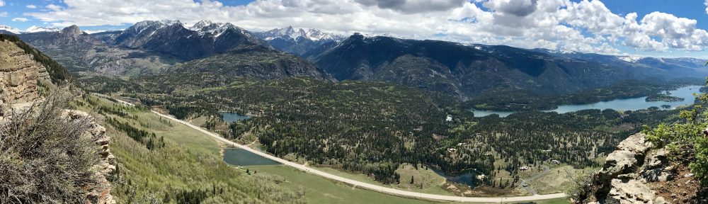
A friend of our’s is often quoted as saying, “I can’t believe I get to live here!” Guess we’d like to remember to say that more often.
View of the West Needles from atop Castle Rock on the Elbert Trail.
As a part of our training for the Haute Route this Fall we knocked off a local favorite just north of Durango overlooking the upper Animas Valley just shy of Purgatory (Durango Mountain Village Ski Area). Just a morning hike of 2.73 miles but the views are outstanding and you’re home in-time for lunch.
I was testing the Gaia GPS app – http://www.gaiagps.com -for my iPhone to see how well it takes and transfers GPX tracks and was very impressed at the ease and simplicity.
Spot On
Making sure the Spot Locater is on, as shown here, before my continuing quest to explore the Great Divide Trail that I started last year. Had to wait until the snow was melted above 10,000, as the first two days of this leg would necessitate camping at that altitude. Fortunately my new Zpacks 20° sleeping bag arrived in time so even if it did dip below freezing (which it did) I’d be toasty in the sack.
This leg was a continuation of the trip from Steamboat Springs (northern Colorado) to Del Norte (50 miles north of the southern Colorado boarder). I’d planned for a 3 to 5 day ride from Del Norte over Indiana Pass (11,910′) on south over a number of other 10+ passes to Abiquiu, NM and then to Cuba, NM and hopefully Grants, NM off I-40 in south central New Mexico.
The ride went well, but I didn’t feel I was making the mileage I had the year before, probably because I didn’t train for the Iron Horse Classic this year. However, last year I didn’t attempt as many or as high passes on the first day so I rationalized the under performance. The new(er) 29’er was superb and my load was well within race weight, even the motor ran well, I just didn’t knock off the higher mileage I’d expected. Weather was perfect starting out, but as all mountain folk know, afternoon thunderstorms are always a possibility and by lunch I had to don my leggings and a rain coat because the light precip was actually snow. By the time I passed over the first range of passes and made to a NewMexico mountain town of Platoro, it started raining and I ducked into a fortuitous cafe for snack and cup of hot water.
Only logged about 70 miles the first day but I did find an excellent camping sport by the river. I must have been tired, as I didn’t consider the colder temps along the river when I chose this site. My tent didn’t seem to have any condensation of the inside until I realized it had frozen and flaked off when stowing the tent.
Second day rose up several more passes and stayed high along the Rio Grande National Forest. This country was absolutely spectacular in it’s views, high mountain meadows and total lack of usage. What a pleasure it was riding thru this high alpine terrain. I’ll have to admit to losing my way twice because I wasn’t paying attention to a couple of turn-offs, but fortunately they weren’t but two miles the first time and one mile the second. Enough to scold yourself for having to climb again where you shouldn’t have.
I did meet a number of cyclists and one CDT thru-hike along the way. The first was a north bound solo rider who racer two years earlier (Bobby from Buena Vista, CO). He was 7 days from the Mexico boarder trying to make the entire route in 20 days total. Nice to compare gear and rigs with him and learn that mine was very comparable. Next I caughtup with 3 guys out of Albuquerque who were “shaking-down” their bike, bodies and gear for a 50 mile section of the same trail I was on. Two of the bikes were pulling Bob trailers and they had at least 55 pounds of bike and gear. I don’t believe they made their goal the first day because I ended up stopping at their campground destination to get water and they weren’t there. I also met a couple cycling north and they were 18 days from the Mexico boarder. I didn’t ask but they probably are planning on the entire summer to complete the 2,900 mile route.
The bad news is that I bailed out at the end of the third day in Abiquiu, NM suffering from a buttock blister that kept me out of the saddle most of that day. It’s hard to inspect the degree of injury but retrospective diagnosis said it was over a silver dollar-sized oozing mess.
For those who didn’t get my daily Spot track I’m including the last 50 GPS tracking locations that the Spot locator provides on line.
Project Mode
Every once in awhile you need to stay home and tackle the project list. Late May has been that time for us. Not to say the “Guilt meter” hasn’t pegged a few times, with decent hiking weather finally arriving and especially NOT riding in the Iron Horse Classic this year.
The good news is numerous projects are completed and it’s almost time to get back outdoors. As you can see our 30 year old cataraft needed some patching, nothing serious but when you have to pump it back up mid-dayon a river trip, it’s time to find those niggling air leaks. Two old patches had micro leaks that we never found on the river, and only after lots of soapy water and driveway conditions, did they show themselves. The Argonaut original will be ready for the Middle Fork on June 26th.
The deck sprinkler system has been installed for the season, we’ve now got WiFi available for the Highlander, teeth have been pulled, the 4Runner has a driver door lock, insurance photos finally made it to a secure undisclosed location, and most importantly the Excel Gear lists have been updated and tweaked. Oh and we now have a fresh decor in the guest bathroom, which has only been on the list since we purchased the condo. That project alone took a week and tools I haven’t used in ages.
All the while we’ve been knocking off projects, the HOA has been tearing up our parking lot to install the “heated” driveway section, which will keep the new Colorado arrivals from experiencing ice on their way to the trash and recycles. This extremely expensive upgrade is schedule to take 3 months and we are now 30 days into the project with the sound of heavy equipment beeping backwards and rumbling with various compactors. Access across the great rubble divide has been challenging not to mention playing the urban city parking roulette on the street. In case you’re wondering that’s 2″ Blue Board insulation placed 8″ below grade so that our new “in-driveway” heating will work as promised.
And just because it doesn’t fit anywhere else, I’ve included my latest MYOG* project for the ultralight gear list. At 1.15 ounces total, these blue foam camp sandals weigh less than a pair of Smart Wool socks. Sure hope they work as advertised!
*Make your own Gear
Sawyer Squeeze Water Filter Fail
Initially excited by product reviews and then by actually weighing and including the Sawywer Squeeze Water Filter system in my ultralight gear, I was disappointed and alarmed to see untreated water dripping and squirting directly into the newly treated water. My hiking companions wouldn’t drink any on my filtered water saying, “your water isn’t clean. I’d rather pump mine.”
This was the first time I’d ever carried and tried my new Sawyer Filter system. I noticed it squirting out of two different pinholes mid-bag on the first squeeze and then saw a steady stream flowing between the nylon filler top and the bag. Good thing we had other filters and Aqua Mira on the same trip. The sparse weight and convenience to quickly filtering water doesn’t do any good if you still get tainted water into the filtered water. I’ve written Sawyer and sent photos of the two separate problems with my 1 liter squeeze bag and not heard a word from the company. A search online shows that other purchasers have had leak problems as well. Most the forum responses suggest using other manufactures bags. Here is a link to other fails (http://www.backpackinglight.com/cgi-bin/backpackinglight/forums/thread_display.html?forum_thread_id=65866). If that’s the case, then paying for the system and 3 included bags in the first place for $49.95 seems like a rip-off. Sure you can buy replacement bags but those will probably leak too since they are exactly the same. And if you need another companies bags why should we pay for 3 Sawyer bags in the first place. Why risk taking a system that will leak and drip bad water into good water?
Spring Arrives
Amazing how Spring can finally burst through like these mushrooms pushing thru the road base of a hard-packed forest service road. I’ve been pushing Spring for about 6 weeks and I finally managed to find a place to get out on the newly rigged mountain bike. With a little guidance I found a loop below the snowmelt line that was within an hour of Durango, and a wonderful place to to shake down the new bikepack rig. We often drive by or even through the area west of Dolores, Colorado but have only hiked off of Lizard Head Pass to the north near Trout Lake. I never imagined how wonderful this lower elevated portion of the San Juan National Forest was for a playground. In fact I had to double take on the name of the forest since the San Juan range is east of the La Platas and this region is well west of the La Platas.
It wasn’t until I’d selected the route that I learned they have a trail over there called Boggy Draw and to this point I’m not quite sure where that trail starts and ends, but I did follow a few Boggy sign markers along the way. I used Garmin Base Camp software and it’s version of geodesic topos, which are literally either too old or too accurate for
contemporary route selection. Garmin will route you along the most direct road between two waypoints, but what many long haul truckers have learned is, that road may no longer be in service. Having a mountain bike is much more forgiving than an eighteen-wheeler, when I ducked under the “road closed” sign and slid down the historic wagon road between several of the waypoints. I only got “stymied” once
when the locked gate said No Trespassing and I had to abort in favor of a state highway. Bike, body and bags held up just fine for an inaugural bash thru the backcountry. I’ll need to add a charging cable to the list if I want to extend the battery life of the Garmin GPS. And I found that the front harness straps loosen, and a skid plate at the bottom of that harness would save the fabric from wear.
The original route was 85 miles as plotted but I’m sure I ran a little over with that one backtrack. As with the Great Divide route the ride was primarily on Forest Service roads, a few logging roads and a stretch of state highway. Early on the forest was so dense my Spot Locater wasn’t picking up a satellite signal but by mid-afternoon the way opened up into vast high altitude grasslands with grazing game and reservoirs. Keeping below 9,000′ was the plan so that there wasn’t any snow and camping temperatures would be above freezing. As with most of my pre-Spring escapades this year it was great making the first tracks on most of the trails, however it also makes for soft ground for the tires which can make handling a bit tricker. It was pure luck to have discovered this route and even better to be one of the first riders this year. Not a single bike tire proceeded me anywhere along the route. I did come across two separate horse riding groups as I got closer to McPhee Recreational Area but not many other recreationalists.
As is customary on these solo ventures, I truly enjoy listening to my selection of Audible Books. Believe it or not I got thru two great books I’m eager to recommend: The One World Schoolhouse by Salman Khan and The Absolutely True Diary of a Part-Time Indian by Sherman Alexie. Wow! both these had been recommend to me and they certainly are worth passing on as great choices. This was the first prolonged test of my iPhone for virtually non-stop listening and after two books (6 hours and 5 hours) plus a number of podcasts, not to mention several photos, the phone was still at 47% battery life. Pure joy to lean against a stump after dinner watching the sun set, listening to a great book. (I had to finish the first one after dark in the tent, it was so good.) And those books sure made the bumpy freshly graded forest service road slip by unnoticed. And yes the sights, sounds and sense remain unhindered.
Grand Gulch
Desert hiking is said to be addictive, but I think it’s just another version of a pastime that offers a glimpse of something many folks don’t afford themselves the opportunity to experience. Fortunately I’ve had the opportunity to visit our southwestern desert this spring with two guys who’ve spent considerable time over the last 30 years in this region, and between them I’ve managed 4 backpacking trips, giving me just a taste of what resources we have 3 – 5 hours from Durango. Our local desert, which I always said begins on the south city limits of Durango (while the alpine high country starts on the the north city limits), is just the place to spend your pre-summer shoulder recreation season.
While it still can be cool at night even on these desert backpacking trips, the daytime hiking temps are superb. (I’ve finally ordered a 20° ultralight sleeping bag to take more advantage of the high desert nights in Spring and hopefully Fall). The first March trips still had snow in the shadows and on some trails we were the first trekkers of the season, stepping on puffy humus trails swollen from a winter of hibernation under the snow. As March rolled on we saw more and more folks making their spring break/cabin fever escapes and taking advantage of desert trails of the southwest just like us. What is totally amazing to us was just how many hikers were from more than 2 full days away from these destinations. Evidently the Pacific Northwest hikers take their Spring break in the American Southwest. And while I’m thinking of it, it’s really worth noting that 96% of the desert hikers we’ve seen so far are over 60 years old, some well over.
The Grand Gulch of Cedar Mesa is so popular the BLM only allows 20 folks a day to enter the area.
Fortunately the groups are generally 2-4 and, like river trips, travel at varying paces and you might only see one or two groups a day, or even none as in our last two days on the trail. Day hikers start on both ends of Grand Gulch trail as there is a popular ruin within 5 miles from each
direction, so after the first major ruin the volume of hikers falls down to the 1 to 2 backpacker groups. Of course the major attraction of Grand Gulch is the abundance of “ancient puebloen peoples” ruins, art panels, glyphs, and artifacts. The Perfect Kiva is a wonderful example of a cliffside kiva community ruin that is totally accessible to any willing to trek down the 1,200′ entry of Bullet Canyon and hike the 5 miles to enjoy Basketmaker living at it’s finest.
You’re able to see some 800- to 1,200-year-old examples of our earliest American settlers just about every other mile of the 30-mile route we choose. Grand Gulch has several access points and one can travel 50 miles if you take the farthest two points. I’ve been most familiar with the southern-most terminus on the San Juan River where we always camp on river trips. We’ve hiked up as far as three miles from the river but I’d never realized the cultural experience further up the gulch. These days not much water travels down the canyons, except those rain- and thunder-storms that frequent the region during the summer and fall. Torrents have been known to rip down these narrow canyons and evidence is rampant everywhere with leaves, branches and entire tree trunks high up on the canyon walls, above sand benches and river bed. One notable point about 28 miles into our hike (and very near the western exit at Collins Springs Canyon) is The Narrows, a 10′ wide “pinch-point” for about 30 miles of south-flowing canyon.Of all the intriguing cultural Basketweaver artifacts we saw, the Big Man Panel is a larger than life-sized graphic of an ancient couple stationed promiently high up on a gooseneck bluff north facing wall. Done in the “Fremont Man” style, this triangular torso’d couple (man with smaller head includes dangling genitals, woman has necklace, purse and waist ornementation) stands not unlike an ancient puebloen people billboard advertising who knows what. Without the hinderance of formal archeological training and study, I’m wondering if these Fremont Man graphics aren’t just how they saw themselves in the spring morning low-light shadows on the canyon walls, rather than the Abercrombie & Fitch models of that era.