Back on the Via Alpina

  
Last year we hiked the Via Alpina from Sargans to Adelboden about 225 miles before we had to return home to Durango.  This year we’re finishing the Swiss portion of the trail, four more days to Lake Geneva.

It feels good to be “thru hiking” again, going from one town to another, always over a pass, which gives you not only grand vistas into and from the next valley, but a sense to accomplishment when you see that last pass way off in the distance.

  
The elevations are a bit lower than earlier in this trip but the daily ascent and descent are just as dramatic. We’ve been averaging about 12 miles a day, when you count getting around town before and after each day’s hike. It’s real interesting to compare all the digital “steps” devices we have (iPhone Health apps and Stanna’s FitBit).  Stanna’s FitBit and my Health app seem to agree most of the time, and to give you an idea they are often both a couple thousand over 30,000 a day when we get in 6 hours on the trail.

  
The last several nights we’ve been staying in very small (5 to 7 room) hotels where we are the sole guests. We like these places better than the larger hotels primarily because of their character and because they’ve managed to remodel older structures into very comfortable accommodations.  This also forces us to search for an evening meal, rather than the half-pension meal provided by the hotel (always very good to excellent) and we’ve lucked out each time finding wonderful meals even though they aren’t four-course.

  
So far we’ve only hiked two days with less than two hours each of rain. It’s been unusually cool and often cloudy, however this has made for very pleasant walking and hardly detracts from the scenery.  Only two more days to Lake Geneva and then we will be finished with the hiking portion of the trip.  Knees, ankles, shoulders and waists are holding up well, despite the abuse. Sure wish we could share the experience “live” with you.

We’ll spend the 17th in Zermatt again for our requisite fondue and meringue  binge.

Swiss National Park

 Unlike the U.S., Switzerland only has one National Park, however it’s easier to understand because it has about a sixth of Colorado’s land mass. (Population is ~8 million to Colorado’s ~5 million). Just think of Estes’ Rocky Mountain National Park as a sole comparison to Switzerland. Rocky Mountain National Park is six times the Swiss park.

  
Established in 1909 and added on to several times it serves as a preserve for a number of animals that had earlier been hunted to extinction. Somewhat like our Wilderness areas they prohibit any human changes to the region and more prohibitively restrict all access to very few specific trails (leaving the trail is verboten). They even have designated rest stops, where yellow topped posts cordon off a half-football field for lunch stops, prolonged resting and viewing wildlife.

  
It’s not quite like Estes Park where herds of elk hang out in meadows, but it is possible to view Ibex and Chamois in their natural settings. We got the feeling it was more like their home and we were on parade up and down those specific trails.

  
Five days was our schedule in the park with one loop, one two-day trek with a stop at the only hut in the entire National Park, another single day loop and then an exit over and out of the park thru a Middle Ages mining district. 

  Their park is quite popular and this is where we’ve seen the most people hiking the same trails as us. One remarkable thing we learned was that their are very few English speaking hikers and even fewer Americans visiting the park. 

  All signage is in three languages and none of them are English; if there is a fourth it’s Romansch.  Fortunately my German has served us well.

Bernina Express

  
Hopefully you’re not viewing the above map on your mobile phone because it’s worthwhile expanding this photo and looking at the beautiful depiction of the eastern Switzerland’s mountains. We had a couple of days of inclement weather and took advantage of them by visiting a glacier up close and then the following day taking a ride on the Bernina express route from Pontresina over Bernina Pass into Italy.

This map by the way, shows almost everywhere that we’ve been for the first two weeks of our trip here in Switzerland. We stayed in Maloja in the top right-hand corner for four nights doing day hikes out of that region and then moved to Pontresina in the center of the map and did day hikes out of there, as well as the glacier and the train trip to Italy. Now we’re down in the lower left-hand corner and the Swiss national Park.

  
The featured Highpoint in this area is being able to see the 4049m peak called Piz Bernina. And one of the many advantages of staying the Pontresina hotels is being given an Engadiner transportation pass that allows you to take the trains, buses and gondolas in the entire region. We had planned to take an easy hiking day by visiting the Morteratsch Glacier from the Diavolezza gondola. There are several short hikes up on top with views of the several other glaciers, however when we made it through the low hanging clouds to arrive at Diavolezza we found 4 to 6 inches of fresh snow on all the trails we planned to hike so we limited ourselves to very short excursions and lots of photo opportunities. We got our daily mileage in by hiking the valley all the way back to Pontresina rather than taking the train.

  
It’s here we saw the long white pillows shown in earlier post where we asked you to guess what they might be. I guessed that they were covering 6 feet of snow so that they would have an early start on the ski season but in fact are preserving the glacier, covering two to three meters of the glacier.

  
The Bernina Express is just one leg of a private railroad system the runs throughout this eastern portion of Switzerland’smountains. This particular route made me think of the comparison between the Durango Silverton narrow gauge as it passes through a similar distance of wilderness in the San Juan Mountains. This route is not through wilderness as it passes through a number of small villages and even towns but it does go through some spectacular scenery and goes over a 2900 m pass, with views of all those peaks and glaciers not to mention precipitous views of valleys. This route has one remarkable featuring where it turns underneath itself as shown above in the photo. We ate our salami, bread and cheese on a park bench in Italy and turned around and came back on the same route and I’ll say it was far less tiring then the round trip on the Durango Silverton narrow gauge.

Guesses?

We saw one of these going over the Surlej Pass and then several up at Diavolezza cable car station near Morteratsch Glacier today.  My guess was close, but still not quite right.  A local Swiss set me straight.

Give it your best guess.  These tarps are at about 10,000′ adjacent to ski areas.


Three Headwaters


Maloja in the upper Engadine valley, just north of the Italian border in eastern Switzerland, has as one of its attractions the hydrological wonder of harboring three distinct watersheds. These local tributaries eventually run into the Danube, the Po and the Rhine and flow into the Black Sea, the Meditterean and the North Sea respectively.

This trip we’re trying something new, basing ourselves in a locale that accesses multiple mountain trails.  The first of our stops is in the Val Bregaglia which is just south of St Moritz and the Swiss National Park.  This valley is historically noted as being part of an early Roman trade route to the north.  It is also noted for some of the earliest Swiss winter tourism and specifically a couple of notable figures like Nietsche and the Italian painter Segantini.


We hiked 13 miles of the Roman trade route to the Italian border the first day, the whole time questioning and conjecturing what they possibly needed from the north.  Later we found from a map that they brought glass all the way from northern Germany as well as tin, iron and gold from southern Germany.  We took the post bus back to Maloya.


Schnitzel with mushrooms, bouquet vegetables and buttered noodles was the reward for our efforts.  We did learn the Romans carried several pounds of grain, hard tack and considerable amount of bacon for their rations.  Not sure if they enjoyed dark chocolate after dinner like we did.

IMG_3146.JPG

The next couple days we hiked in different directions, one day up long Val Fex with hanging glaciers at the top and a couple of picturesque resort hotels accessible only by horse-drawn carriage.  A hike around the Silsersee took us high up on one side giving us views of the craggy mountains and the lake below which lies between Maloja and Nietsche’s summer town of Sils Maria.

In each day’s hike we traveled through tiny mountain-side hamlets and even smaller alp farms with their famous chalet-style huts and rock and timber barns.  Just a reminder, the word “alp” refers to those high meadows up in the mountains, not to the mountains themselves often called The Alps.


Swiss Bound

IMG_7345Off on another “Birthday Hike” in Switzerland.  The kitchen “gear” scale has been utilized full-time this week paring down weights of containers, tops, shoes, etc.  Since we only tote day packs it’s tight when some of us have 3 pair of shoes, but if you average the two packs we’re still within the 10# range.

Itinerary this year is more varied, with us exploring the eastern Switzerland National Park initially, and then finishing up the Via Alpina between Adelboden and Lake Geneva in the western portion of Switzerland. And a bonus side trip to Belgium.

We’ll try to blog along the way – photos don’t get formatted or aligned – but we should be able to write and record as we go along.  Caution: there will most likely be some food-p0rn since we like to enjoy some of those meals and dishes several times by looking at them over and over.

SatelliteYou can always see where we are by clicking on our Spot Location on the blog main page, and we recommend changing the view to Satellite in the right-hand corner of the map.ArrowTracking

If you can’t get the blog main page because you’re viewing on a mobile device, the URL is here.

Spot Gen 3Spot is a GPS location beacon that records our track every 10 minutes.  We’ll try and keep it activated each day we’re hiking.  Weight 4.5 oz.  House guest, web cam and Roomba will be watching home.

Late May Early June

It seems like we haven’t been doing anything when we haven’t posted a blog. Normally there’s always time to sit down and write about what we’ve been doing and what we hope that you would be doing: having fun, exercising and getting outside.

IMG_2310

Right now we’re in Portland working on Daniel’s new house, rather his new old house, which was built in 1888. But before we get into the remodel in Portland let’s just tell you that we had a busy week just before leaving for Portland. Week before last Stanna’s IMG_2318brother David and his wife Pam came down from Denver. The weather cleared enough for us to do a great 5-mile hike right in one of Durango’s mountain parks. As you can see “Durango records wettest May on record” so it wasn’t possible to get out much at all.

Besides catching up with news about their family, grand-babies and recent wedding adding a fourth spouse to their five grown children, David & Pam took home some of our purged loot. Best of all is  knowing the 60-pound dish-packed box of Beekley China will have a home at their cabin in Estes Park.

IMG_2339First on our agenda in Oregon, before tackling the house remodel, was catching up with Polecat.  Don & Janice just happened to roll their only home into a Portland state park the day before we arrived.  We all had to get out, even in the rain, so we hiked a popular Multnomah Falls Loop trail.  They had eyed a fresh fish market earlier and hoped the skies would clear long enough for a fresh salmon barbecue.

IMG_2351IMG_3338

IMG_2355

IMG_2532

Daniel’s new house in SW Portland, located on a hillside overlooking the Willamette River, was built in 1888. His plan is a total remodel of the basement and two floors, that includes gutting of the kitchen and entire second floor. The short-term goal is to get moved in by August 30 and that would mean making the main floor totally livable with an entirely new kitchen.

IMG_2400We arrived in time to be involved with the demolition work in the upstairs: only took one hard day to take out every wall of the second floor. Gutting the kitchen was a little more involved and took about three days, because I had to remove appliances cabinets, plumbing and soffits. Daniel originally thought it would only require a 10 yard dumpster but I think the pile is now close to 20 yards.

IMG_2394Since his house is over 120 years old it had multiple layers of wallpaper, in some places as many as eight. We rented a steam wallpaper remover and it took a full seven-day rental to remove the wallpaper from the first floor walls that were over 10 feet high. Many places we could only get down two or three layers to an impermeable layer which Daniel is IMG_2369just going to sand and paint. Most of the interior construction is with lathe and plaster but the serious remodels show the various stages of sheet rock from the earliest types to the more modern.  The first-generation sheet-rock with the brown paper covering absorbed steam too easily and prevented us from taking off a layer of wallpaper directly attached to that oldest drywall.

IMG_2382IMG_2393 (1)This trip coincided with the end of school here in Portland so we got to see a number of functions for our granddaughters, the most interesting of which was at Sophie’s elementary school where she participated in a fifth grader “states float” parade and the final day “clap-out.”  Clap-out was pretty remarkable because all the younger elementary school students IMG_2450and parents of the fifth-graders lined the central school hallway as the fifth grade graduating students exited their classrooms and received a clap-out and high-five from all the gauntlet of well-wishers.

IMG_3464Our final project at the house was ringing-out and planing the remodel’s wiring. Lots to be upgraded and since they’re going to finish out the basement as well, a number of new circuits need to be added. Two weeks in Portland sure went fast.


Home Again

IMG_2123Several folks have written to see if we made it home yet, probably since there hasn’t been a posting about a departure or an arrival in Durango.  

A number of well-wishers from the Trang Cycling Club came to the local airport to see us off, and load us up with sweet pastries for the flight home.

We’ve now decided that the best day to fly is on a Tuesday, because the Bangkok to Tokyo flight wasn’t crowded and the Tokyo to Denver flight was only 2/3’s full, leaving the center seat in almost every row of three seats empty.

Wassana guesthouse now has a red plastic storage box of those items we buy each year to make our room living more comfortable: such as tableware, food storage containers, a yoga mat and exercise ball.  The bikes are back at out friend’s house and should be available next year, which we currently think will be 3 months – Jan thru March.

We managed to come home with less than we took over, even though we brought home a little more Thai textiles and some Panang Curry ingredients. We just can’t imagine what’s in those large roller bags most travelers lug around, although truth be told, Stanna did check a backpack on the trip home.

2 Drone Week

IMG_2097Yet another bicycle parade and this one was flanked by vintage motorcycles, restored volkswagens and the town’s Tuk-tuks.  Most of southern Thailand’s economy is founded on harvesting rubber from it’s rubber tree plantations, not to mention rice and palm oil, but rubber trees grow best in this region of Thailand primarily due to it’s latitude and associated climate.  There doesn’t appear to be Agri-Business managing and producing all these tens of thousands of hectares of patch-work, mostly small family-owned groves of trees planted on old flat rice fields as well as on the hilly inclines.

parade2In 1899 a provincial governor who had travelled “abroad” brought the first rubber trees back to stimulate Thai agriculture, and planted them just down the road from Trang in Kantang.  This parade and celebration was for Rubber Tree Day and constituted the biggest parade we’ve seen, or been a part of, since visiting Thailand.  All the various parading constituents met at different locales around town and coalesced at Trang’s largest stadium fairgrounds, where gigantic gymnasium-sized tents covered agricultural displays, food stands and fair attractions.

One massive display on the fairgrounds we only saw the end of, as we cycled in thru the center of the grounds, was an elephant pulling a giant stone roller that was used to build the roads over the mountain passed between the peninsula’s coastal regions.  Sorry no photos, as the elephant was discharged while all 250 bicycles were herded to the forefront of a concert stage.  SunSern explained that before the use of dynamite they would “fire” (heat) the boulders in the way of a roadbed and then pour water on them to crack the rock. Then the labors would “cut and fill” and the elephants would “roll” these Flintstone-sized rollers (almost the size of those VW bugs in the parade) to smooth out the roadbed.

IMG_2105Besides the transport-mode participants in the parade, there were quite a number of flatbed truck-mounted floats depicting the various stages of Rubber Tree development including taping the rubber water and pressing the liquid into the door-mat-sized product we see drying adjacent the plantation’s family mangle-looking presses throughout this region. Now-a-days, the rubber water is more often collected daily from plastic 20-liter containers into 50-gallon drums and then later in the day pumped into pick-up-mounted 300 gallon tanks and finally taken to a wholesaler who fills a 20-wheeled tanker truck. Mat production only occurs in areas where access to daily trucking is limited, like the islands and deep in the hill country.

Mat rubber is used for the heavy rubber production of items like tires, whereas the liquid rubber can be used to form “finer” items like gloves and gaskets.  Thailand ranks 1st in world natural rubber production, however synthetic rubber production has outgrown the demand for natural rubber.  Between synthetic rubber and competition in neighboring countries the price of rubber has just recently dropped from 180 Baht a kilo to 30 Baht.

IMG_2101This was the second time in three days that we were filmed by a drone-mounted GoPro.  I guess this is the norm for ariel photography and works well with parades and large gatherings.


IMG_2108We didn’t stay for the food fair provided to the participants.  SunSern and his wife took us to a favorite Thail restaurant where we gorged on delicious dishes, some familiar and other new, like the pounded catfish that explodes into a light puffy bird’s nest of taste when poured into a wok of palm oil.  It’s topped at the table with grated mango in fish sauce.  A Roi.


Extra

“What time are you finished riding with Fashung?  Are you available for a ride at 7 AM?” was the call after I’d gone to bed Tuesday night.  “They want riders to make a ‘Live’ movie about Trang for TV.”  “Sure, I’ll be there” I volunteered.  What I didn’t realize was Trang is having it’s Centennial on April 14th and they want to have 1,000 cyclists come and cycle around Trang, so they are making a “Promo” for TV Channel 22 showing the Trang highlights.

Film 2Extras evidently spend a lot of idle time waiting around for the film crew to arrive and then set-up their various cameras, and “shots.” Never-the-less we still got in about 20 km of cycling, sometimes just going round and round a park or monument.

It was fun, and seeing them deploy a camera drone above our group was fascinating.  Curious to see how that footage turns out, however they weren’t showing our riding “live” and don’t plan to broadcast the film until the 8th, one day after we fly home. So we’ll never really know.

Since I couldn’t really photograph my participation in the filming I’ll have to post several photos posted on local Club members’ FaceBook pages.

Film 1film4All told, we were filmed cycling at five attractions within the city limits of Trang. There were 20+ riders on a variety of bikes, most of whom wore one of two Club jerseys. They did feed us twice and it’s wasn’t a box lunch, rather a 5-course family style lunch at a well-known local restaurant.

Travertine Pools

IMG_2081Quite a mixture of experiences this last weekend, which is fitting because it was our last full weekend in Trang.  Next weekend we’ll be heading to Bangkok on Sunday in preparation for departure to Durango on Tuesday. Ever since we got waylaid in 2011, heading north when local flooding stopped our train in it’s tracks, we now stage our departure at least a day early to Bangkok.  This year the flooding is in Bangkok, so you never can never tell.

One last bike camping trip was on the agenda for this last Sunday, while Stanna took a trip south to our friend Chalong’s family gathering.  I’d accompanied the Cycling Club to marshal in the Sai Rung Waterfall Fun Run in years past, but this one was more special as more than a hundred Trang cyclists came over early Sunday morning to join us at the event.

IMG_2033What those cyclists missed on Saturday was hiking up the famous Sai Rung Waterfall (or infamous if you want to mention the historic flash flood there that killed 38 in 2007).  All-granite cascades of falls and ponds roll down (or up in our case) hundreds of meters providing vistas, ponds, slides, pools for swimming and slick rock scrambling.  Mists from the falls shine with rainbows giving it the name “Rainbow Waterfall”.

bottlesOne of the best experiences was standing chest deep under a pounding falls that kneaded your shoulders and neck.  Once again my Thai friends that don’t swim had their 4-one-liter-bottle-belts serving as PFD’s. I towed one cyclist across the pond to the falls so he might enjoy the massage too.  Frolicking in waterfall ponds is an often sought destination for our Sunday weekend tours, and there are quite a number to choose from in the vicinity of Trang.

Preparing food for wake

Preparing food for wake

In the meantime, Stanna (also unaware of just what her “field trip” was about) went with Dr. Chalong (she just last week defended her dissertation in English – she is the Thai lady who visited us in Durango last summer), to attend her uncle’s wake.  Evidently the Muslims hold a wake or memorial 40 days after the death and all acquaintances are invited to stop by.  Giant caldrons of food are prepared and served to the guests in respect for the deceased.

The only other similar celebration we’ve attended was one for a past prime minister’s mother here in Trang in 2012, and that was attended by thousands, with bus-loads of “respect-payers” coming from all over the southern peninsula.  This one was smaller by comparison, but even in this tiny village drew several hundred.  We see these events every day in Thailand, where a large tent is set up adjacent to a house, generally taking up one lane of the roadway, with tables and chairs for the attendees but we rarely get invited to attend.  Depending on the religion you might see the elaborate flower-decked refrigerated coffin in situ in the carport.  Muslim passed are buried within 24 hours.
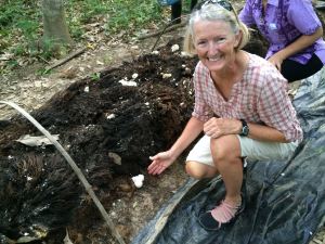
IMG_5848All these southern Thai communities have a mix of palm oil or rubber tree “water” as their source of income, and until rubber water dropped to a sixth of it’s price.just recently all land owners have been quite prosperous. Chalong’s family has IMG_5842added a bonus to their rubber tree groves by raising mushrooms in rows between the trees. The mushrooms can be picked daily.

IMG_2075After the 5, 10 and 20K Fun Run the entire cycling contingent rode 30 km to a rural school to present donations of school supplies and sports equipment given by the Trang Tourism Board, banks, other schools and various cycling groups.  Thai’s are prolific in their presentations with speeches and recognition of everyone and their sisters.  Even I got to “present” a gift (twice) to students who dutifully paraded up for photos with the donors.

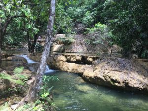
The finale of the day was cycling to a nearby waterfall that is not on any paved or dirt road.  40 or 50 of us followed several guides up rivulets of swampy jungle streams until we came to travertine dams and pools which got grander in scale the farther we pushed up the mountain.  This was veritable jungle with

IMG_2082mangrove sized roots blanketing the ground creating fallen leaf covered hidden puddles of muddy water.  Tarzan-like vines hung down everywhere you passed and if it wasn’t uphill you could swing forward as a navigational aid.  The only solid footing, besides a dry tree root, was the limestone edge of the travertine walls. IMG_2080My cleated Keens made secure footing problematic, but far better than for those in regular bike shoes.  Half-way into this mire, many of us realized it was time to wrap-up our cameras and phones in case of inadvertent dunking caused by a slip or fall. As a consequence not many photos document the travertine traverse up the mountain.